
Operational Transformation with GIS
Digital transformation of legacy mapping of broadband networks to a more spatially intelligent option has led to geographic information system (GIS) transformation in telecommunications. New methodologies have been implemented for activities such as plant maintenance, extensions and troubleshooting. Midco and many of our cable industry peers continue to enhance geospatial architecture by integrating with other systems. Depending upon the data within the system, it can also drive process improvement through the rest of the organization.
GIS is no longer a system of record but has become one of engagement and insight. Rather than simply reading and displaying data, GIS maps are the authoritative source for many datasets and are changing the way users interact with this data.
GIS Evolution
Ever since web mapping became more prevalent, GIS has been increasingly transitioning to a system of engagement. In the past, viewing interactive data and running analyses were confined to a heavy desktop application that only specialized GIS staff used. Visuals were exported to an image file to be shared, and data was exported to spreadsheets.
Web mapping has completely transformed the way that end users interact with spatial data. This change is brought about with the simple to use interactivity of the map, such as panning and zooming, and also more complex functionality, like filters and queries that allow users to easily view the data they find most useful.
GIS web and app experiences are an increasingly common part of work and personal life for nearly everyone. Using navigation apps and devices for driving is just one way the mystery has been taken out of GIS, making it more physically and psychologically accessible than ever.
Beyond engagement, GIS has also entered into a new era of data insights by adding the spatial dimension to analysis. This has also evolved beyond a desktop app for a select few. Today, we can easily share the results of complex analyses, pushing them to web and cloud-based tools, and enabling users to perform their own analysis on demand. Specialized GIS staff are still integral in deploying these tools for end users, but accessibility to these tools has never been easier. With the rise of big data, there’s been the need for a more distributed architecture, as performing this type of analysis on a single standing desktop or server is no longer viable.
Transforming GIS from only a “system of record” has also gained more buy-in from end users whose jobs are to keep the data up to date. They are seeing the direct benefits of collecting and updating useful information.
Transforming Telecom
Impacts from overall GIS industry trends can be seen within the telecommunications-based GIS space. Prior to GIS, Midco and many other companies used computer aided drafting (CAD) maps, which provide a view-only look at the network. As this data continues to migrate from those systems to GIS, new information is being created and analyzed. GIS has the ability to understand network topology, making it possible to perform some pretty amazing things — such as tracing of an individual wavelength and all the network equipment it passes through. Similar to the larger GIS industry trends, this started on the desktop and has moved into web and mobile technologies — providing unprecedented access to network information whenever one chooses to access it.
From the system of record standpoint, integrations with billing, proactive network maintenance (PNM) systems and locate ticket systems allow GIS to become either the authoritative source for information, or easily participate in sharing it with other systems. Integrations usually hinge upon connecting some sort of overlapping information in the systems. Maintaining this link among systems is key to a successful integration.
The broadband cable industry has an abundance of GIS use cases. This includes many opportunities, such as coordinating field personnel, providing in-depth spatial analysis on build-outs, finding the best possible opportunities for sales teams to pursue, and tracking network infrastructure. When deciding to use GIS for broadband networks, you should ask yourself two questions: Where do we start and what are our most pressing use cases?
When you’re considering your use cases, be sure to consider how end users will easily engage with up-to-date information in an on-demand format. Engagement goes even further by giving operations users new tools that were never available in the past. Of course, making this transition to a system of engagement and insight also requires records be accurate and provide worthwhile insights. The old adage, “garbage in garbage out” absolutely applies to geospatial data. The system of record also needs to be complex enough to support future use cases. Everything really hinges upon the underlying data quality and model. It’s common to find errors in the data when converting from tabular to spatial. Inaccuracies formerly undetectable by looking at tables or spreadsheets often will quickly reveal themselves when viewed spatially or entered into a network topology.
GIS is already giving insight into new ways of looking at network congestion and health. For example, at Midco, we’ve used GIS to consume data from cable modems and then spatially displayed that data. Within the same application, we compile and display data usage by address for a number of time windows (one month, three months, six months and 12 months) — and show that proportionally to points on the map (Figure 1). The map gives insights into the top 10 data users, with the ranking showing per node. This data set enables city heat maps showing which regions have the highest data usage. In addition, we can transform the data into a space-time cube, where in-depth analytics and machine learning can identify spatial trends over time. Ultimately, this enables better predictions of where network usage will increase at a faster rate — and that will help broadband network providers make more informed and better decisions on where and when to augment the network. It also can help providers determine troublesome areas and anticipate where future issues may arise.
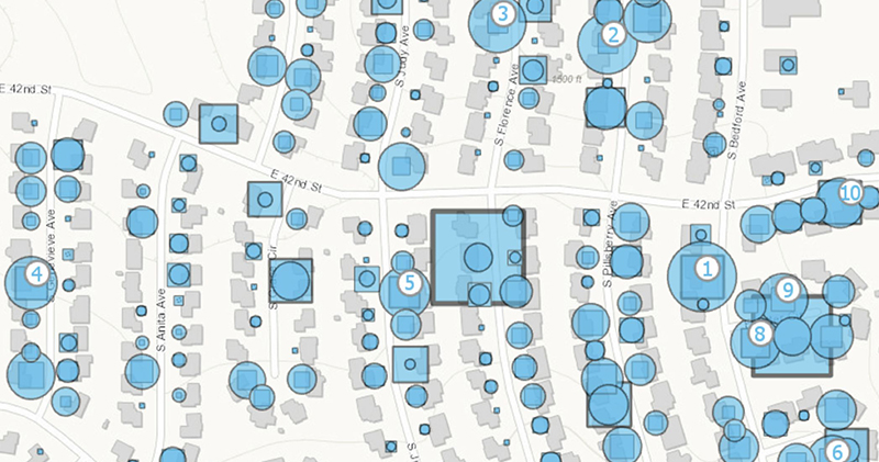
Figure 1. Data usage by address, total usage, and rank within node on an interactive GIS App
Augmented Reality, Artificial Intelligence and More
Augmented reality (AR) is a large, tech industry trend finding its way into both GIS and the telecommunications industry. Several companies are working with this up-and-coming technology so users can view underground assets from their phone or tablet. Additionally, this technology can be used in data centers to show information about equipment that otherwise would have to be labeled, and you could even change the equipment details in real-time. Just like other GIS tools, the success of this technology fully depends upon underlying data accuracy. For example, AR for underground locations requires accurate spatial location data if GIS is going to provide meaningful insights.
Two other emerging technologies, artificial intelligence (AI) and machine learning (ML), will be used to give even greater insight into the day-to-day running of a broadband network. For example, if you feed network traffic and cable modem level information into a ML algorithm, you could potentially predict where future network augments need to be performed and predict future network outages. There is still much more to be done to make these techniques commonplace within the industry. GIS has a key role to play with these technologies since it can bring the spatial dimension into consideration. Beyond just clustering, the complex network topologies of a telecommunications network can be leveraged to better manage network growth and congestion.
GIS adds a visual element to analyses while detailing powerful stories. However, GIS goes far beyond to serve as an engine that examines data through a spatial lens — in ways not possible in standard reporting software. As more systems and workflows integrate with GIS, the problem-solving possibilities will increase. If you want to grow GIS in your organization, choose a use case that is spatial in nature and then create the data, systems and processes needed to solve that situation. Then, you can evolve the tool for something completely new — and do that again and again. All this leads to the increased investment, use, visibility and influence of GIS — but even more importantly, it can help transform your organization.
 Derek Rieckmann,
Director of GIS,
Midco
Derek Rieckmann is the Director of GIS at Midco, a Midwest network provider serving nearly 400,000 residential and business customers. Rieckmann leads a GIS team that pushes the company, the industry and the GIS discipline forward into new technologies and opportunities. He earned his bachelor’s in geography from the University of Northern Iowa and his masters in geography from Western Illinois University